
 Harvard-MIT hike at China Camp
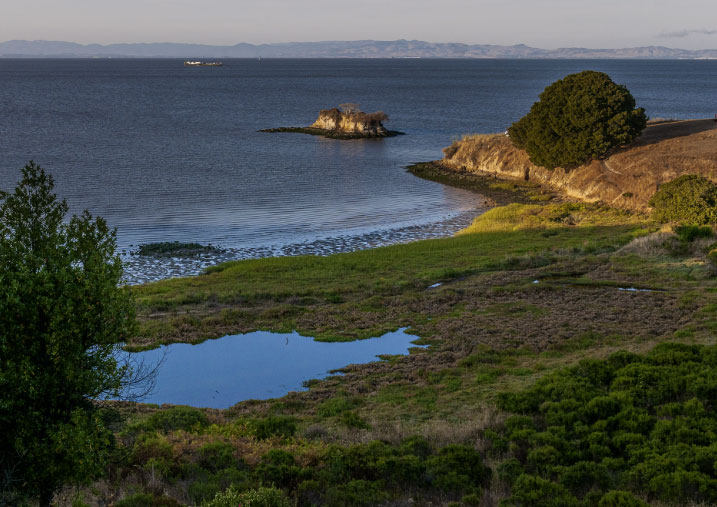
Beat the heat with a cool summer hike offering panoramic views of the the waterfront and lots of wildlife
Distance: ~ 8.0 miles (there is a shorter 6.6 mile option, check with me on this)
Elevation Gain: 1000' Moderate
Est. Time: 5 hours
Restrooms are available at the trailhead and at several points along the hike (see park map).
Dogs are not allowed on the trails.
Description:
Nestled along the shore of the San Pablo Bay, China Camp State Park offers magnificent panoramic views of the waterfront and miles of multi-use trails. Features include an extensive intertidal salt marsh, meadow, and oak habitats. There is a variety of wildlife, including deer, squirrels, coyote, fox, bats and numerous birds.
A Chinese shrimp-fishing village thrived on this site in the 1880s. Nearly 500 people, originally from Canton, China, lived in the village. In its heyday, there were three general stores, a marine supply store and a barber shop. The museum at China Camp Village helps tell the story of these hardy shrimp fishermen.(From Friends of China Camp)
China Camp Village was also used as a setting for filming the 1955 John Wayne movie Blood Alley.
We have arranged a short docent-led tour of China Camp Village at 10:15 AM, just before the start of the hike.
Hike Details:
The hike heads west from the parking area on the Shoreline Trail. In 0.7 mile pass the Ranger station and head uphill on the Peacock Gap Trail for a short distance before branching off on the Oak Ridge Trail. The Oak Ridge Trail climbs steadily then levels off before ending at the Bay View Trail. (An optional 0.5 mile side trip on the McNears Fire Road takes us to a scenic lookout with a spectacular 360 degree view.) We follow the Bay View Trail to its junction with the Back Ranch Fire Trail which takes us down to our lunch spot at the Back Ranch Meadows Campground. Here there are restrooms, running water and picnic tables. This is approximately the halfway point. From here it is 4.0 miles back to the parking area along the Shoreline Trail.
A brochure with map of China Camp State Park may be downloaded at https://friendsofchinacamp.org/wp-content/uploads/2021/04/ChinaCampSPWebLayout2015.pdf
What to Bring:
Start your day with a hearty breakfast. The trails are mostly shaded with a bit of sun exposure, but it is always good to pack sunblock and a hat. Water is available at a couple of places along the hike but it would be prudent to carry a quart or two especially if it is a warm day. Proximity to the bay means it can get breezy in the afternoon so a windbreaker is a good idea. Bring snacks and a lunch.
Rain policy:
If there's any ambiguity about the weather on the day of the hike, you can check the forecast the morning of the hike. The NWS forecast for China Camp State Park may be found at https://forecast.weather.gov/MapClick.php?lon=-122.48545646667482&lat=38.00090176789115#.W2Pb234nbDY
Directions:
From 101 north in San Rafael take exit 454, North San Pedro Road. Follow San Pedro Road East about 5 miles to the China Camp Point parking area on the left.
Google Earth coordinates: 38º 00' 7.34"" N, 122º 27' 42.84"" W
Driving time: ~30 minutes from the Marin side of the Golden Gate Bridge or from the toll plaza of the Richmond San Rafael Bridge
Parking: $5.00 parking passes are purchased from a machine. It takes cash but does not
Saturday, July 26, 2025
10am - 3pm PT
HCSF Members: Free
Non Members: $5 Not a member? Register here for membership!
Click here to register
Event Registration (Harvard Alumni):
Please sign in with your HarvardKey otherwise a duplicate record will be created and you will not be able to log-in.
No HarvardKey? Please retrieve your HarvardKey here. If you need help, email ithelp@harvard.edu or call 617-495-7777
HCSF Guidelines for attending in-person events
If you are showing COVID-19 or Flu symptoms, please stay home. This is critical to the health and safety of our staff and communities.
Event Organizer:
Alexandra Morehouse
alexandra.morehouse@gmail.com