
 Steep Ravine Hike
Come hike the legendary Steep Ravine trail, through redwoods and out to the coast
10:00 AM at the Pantoll ranger station in Mt. Tamalpais State Park
Distance: ~ 7.6 miles
Elevation Gain: 1500' Moderate
Est. Time: 6 hours (including some time at the beach)
$8 per car to park at the Pantoll ranger station, cash only.
This parking lot fills up early on nice weekends, so arriving 15 to 30 minutes before the start of the hike (9:30 to 9:45) is a good idea.
Restrooms are available at the Pantoll ranger station and at Stinson Beach.
Dogs are prohibited in Mt. Tamalpais State Park.
Description:
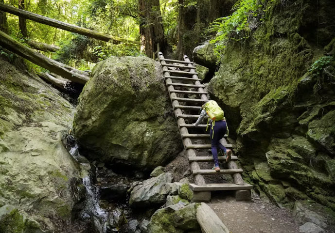
Mount Tam’s legendary Steep Ravine Trail leads hikers along Webb Creek through a stand of tall redwood trees. The sound of rushing water prepares visitors for the fragrance of damp earth and the sight of ferns along the creek’s banks. The redwoods form a canopy above the water cascading over the rocks. Alongside the cascade, hikers must climb a steep ladder to return to the beginning of this beautiful trail.
The hike starts at the Pantoll Ranger Station at 1500' on Mt. Tamalpais (the main peak of the Marin Headlands, overlooking the Golden Gate). We will head down the Matt Davis trail, which is not as steep and has excellent ocean views.
This takes us to Stinson Beach, where we can have lunch, spend a bit of time frolicking in the surf and generally cool off before we head back uphill on the Steep Ravine Trail. This part is the main attraction -- it climbs up through very deep, very beautiful, very prehistoric looking redwoods, ferns and cool shade on a sunny day.
What to Bring:
Although the Steep Ravine trail is very shady, the Matt Davis and the small segment of the Dipsea aren't. Sunblock and a hat are recommended, along with plenty of water (at least 2 quarts per person) and some snacks. Bring a bathing suit and towel if you are planning a dip in the ocean. Stinson Beach is our lunch spot. There are picnic tables and restrooms. Pack a lunch or buy one there. Two nearby possibilities are the Stinson Beach Market at 101 Calle Del Mar and The Lunch Box at 15 Calle Del Mar.
Directions:
Take Highway 1 in Marin to the junction with the Panoramic Highway. Turn right on Panoramic and continue uphill for 5.5 miles (past the turnoff to Muir Woods) to Pantoll Rd. Turn left at the parking area, where you'll find the Pantoll ranger station and trailhead.
We will meet in the clearing to the left of the ranger station, near the window where you pay your parking fee.
If the Pantoll parking lot is full, there are a few other areas where you're likely to find something -- just up the hill on Pantoll Road, 1/4-1/2 mile downhill on Panoramic Highway, back the way you came at Bootjack, or -- worse case, you can usually find something at Rock Springs.
NOTE: Cell phone service is marginal at the ranger station.
Google Earth coordinates of Pantoll Ranger Station:
37°54'13.23""N 122°36'14.54""W
Driving time:
Approx. 45 mins from the San Francisco side of the Golden Gate Bridge. Probably 1:45+ from the Valley. Leave an extra 15 minutes or so for parking issues.
Rain policy:
If there's any ambiguity about the weather on the day of the hike, you can check the forecast the morning of the hike. The NWS forecast for Stinson Beach may be found at https://forecast.weather.gov/MapClick.php?lat=37.8985&lon=-122.6392#.XSOIOHt7nrI
If it's raining significantly, the hike is off. If the weather is ambiguous, we will send out an email to all that have RSVP'd
Disclaimers:
Joining any hike is entirely voluntary and participants assume any and all risks associated with the activities. By registering or attending this event, participants agree to the conditions posted at: http://northerncalifornia.alumclub.mit.edu/s/1314/images/gid25/editor_documents/event_documents/liability_waiver.pdf
Meet at the Pantoll ranger station. Take Highway 1 in Marin to the junction with the Panoramic Highway. Turn right on Panoramic and continue uphill for 5.5 miles (past the turnoff to Muir Woods) to Pantoll Rd. Turn left at the parking area, where you'll find the Pan Toll ranger station and trailhead.
We will meet in the clearing to the left of the ranger station, near the window where you pay your parking fee.
Saturday, November 15, 2025
10:00am - 4:00pm PT
HCSF Members: Free
Non Members: $5 Not a member? Register here for membership!
Click here to register
Event Registration (Harvard Alumni):
Please sign in with your HarvardKey otherwise a duplicate record will be created and you will not be able to log-in.
No HarvardKey? Please retrieve your HarvardKey here. If you need help, email ithelp@harvard.edu or call 617-495-7777
HCSF Guidelines for attending in-person events:
If you are showing COVID-19 or Flu symptoms, please stay home. This is critical to the health and safety of our staff and communities.
Event Organizer:
Alexandra Morehouse
alexandra.morehouse@gmail.com