
 Hike in the Sunol Wilderness
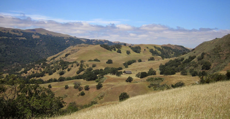
Join us for a scenic hike through Sunol Regional Wilderness, a hidden gem in the East Bay
Join us for a scenic and moderately strenuous hike through Sunol Regional Wilderness, a hidden gem just off I-680 in the East Bay. This joint hiking event brings together the MIT Club of Northern California, HCSF, and friends for a day of exploration, great conversation, and fresh air on the trails.
Who Can Attend
This event is open to all Harvard alumni and guests; HCSF membership is not required. This is a joint event with the MIT club of Northern California, and friends from both communities are welcome.
Registration is open to everyone, please register in advance.
Hike Overview
Start Time: 10:00 AM
Starting Point / Meeting Location: The Camp Ohlone Road Trailhead
📍 Map: https://maps.app.goo.gl/qutsAHsgABmSwYBL9
Route: Camp Ohlone Road → Backpack Road → McCorkle Trail → Cave Rocks Road → Indian Joe Creek Trail
Difficulty: Moderately strenuous
Distance: 7.0 mile round-trip, 1,000' elevation gain.
Estimated Time: 4.0 - 4.5 hours, including a lunch break.
Note: Please be sure that you are comfortable with the distance and climbing before joining us. Those preferring a shorter route can walk an easy out-and-back to Little Yosemite, < 3.0 miles.
Cell phone reception at the trailhead may be unreliable, so please review the park map in advance
Brochure and map for Sunol Regional Wilderness can be found at: https://www.ebparks.org/sites/default/files/Sunol-brochure-2025-04.pdf
About the Park
Sunol Wilderness is a regional gem located just off I-680 in the East Bay. Its geology features sandstone outcrops with fossils deposited in what was once an ancient seabed. Large boulders of greenstone, schist, and metachert hint at a turbulent past. The massive basalt outcrop at Indian Joe Cave Rocks offers sport and challenge for rock climbers.
Alameda Creek, Alameda County's largest stream, supports a lush creekside community of alder, willow, and sycamore. Coast live oaks abound, along with valley and blue oak, elderberry, madrone, and gray pine. In spring, wildflowers, including California poppies, mustard, goldfields, and lupines, carpet vast areas in vibrant shades of yellow, orange, and blue.
Wildlife is abundant: ground squirrels, yellow-billed magpies, and red-tailed hawks share this wilderness with raccoons, skunks, and black-tailed deer. Mountain lions are uncommon but are occasionally sighted. Birding is superb along Alameda Creek, with acorn woodpeckers, black phoebes, titmice, turkey vultures, and golden eagles frequently observed.
Little Yosemite, a scenic gorge on Alameda Creek, is an easy walk from the trailhead.
What to Bring
- At least 2 liters of water
- Snacks and lunch
- Hat, sunglasses, and sunblock
- Long pants, tall socks, and closed-toe hiking shoes
- Layers for changing weather
- Hiking poles (optional but recommended)
Rain/Weather Policy
If significant rain is expected, the hike will be cancelled. If the weather is ambiguous, we will send out an email to the registered participants on the morning of the hike.
If there is any uncertainty about the weather on the day of the hike, please check the forecast on the morning of the hike.
Important Disclaimer
Joining any hike is entirely voluntary and participants assume any and all risks associated with the activities. By registering or attending this event, participants agree to be fully responsible for accepting all such risks.
Because this event is in person, you acknowledge the below by coming to this event.
I acknowledge and understand that:
(i) I am not required to participate in this event;
(ii) my participation is voluntary and at my sole risk;
and (iii) I am entirely responsible for my own health and safety.
🗺️ Directions:
To the park (do not rely on navigation systems):
- From Fremont or points south: Drive north on I-680 and exit at Calaveras Road (near the town of Sunol.) Turn right at the exit onto Calaveras Road and proceed about four miles to a left turn onto Geary Road, which leads directly into the park. (If you find yourself driving uphill on a narrow winding road you've missed the Geary Road turnoff.)
- From the San Francisco-Oakland-Berkeley area: Drive east on I-580 to the junction with I-680. Take I-680 south and exit at Calaveras Road/Highway 84 just south of theSunol exit. At the bottom of the exit turn left onto Calaveras Road and proceed as noted above.
- From the Walnut Creek-Danville area: Drive south on I-680 and exit at Calaveras Road/Highway 84 just south of the Sunol exit. Proceed as noted above.
- To the trailhead:
Once inside the park, drive along the only road in the valley which eventually becomes a one-way loop. The Camp Ohlone Road trailhead is at the farthest point from the park entrance along this loop.
Logistics
🚗Carpooling is strongly encouraged, due to limited parking at the trailhead.
Join or create a carpool using this link: https://www.groupcarpool.com/t/8vhmr4
🐶 Dogs are permitted in the park
🚻 Restrooms are available at the trailhead parking lot
💲Parking Cost: $5 (Please bring cash)
Date
Saturday, February 7, 2026
10:00am - 2:30pm PT
Tickets
HCSF Members: Free
Non Members: $5 Not a member? Register here for membership!
Click Here To Register
Event Registration (Harvard Alumni):
Please sign in with your HarvardKey otherwise a duplicate record will be created and you will not be able to log-in.
No HarvardKey? Please retrieve your HarvardKey here. If you need help, email ithelp@harvard.edu or call 617-495-7777
HCSF Guidelines for attending in-person events
If you are showing COVID-19 or Flu symptoms, please stay home. This is critical to the health and safety of our staff and communities.
Event Organizer
Alexandra Morehouse
Alexandra.morehouse@gmail.com